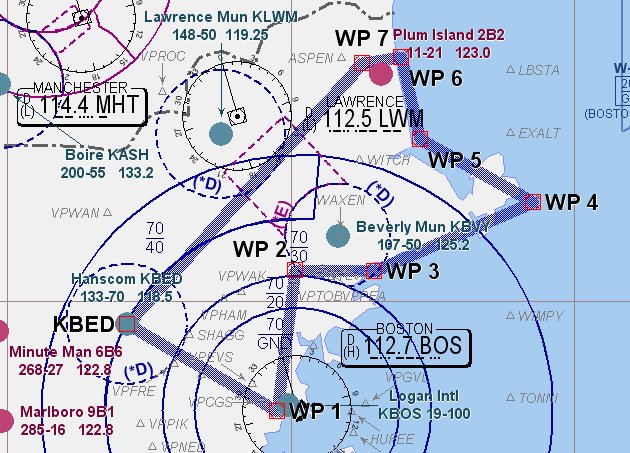
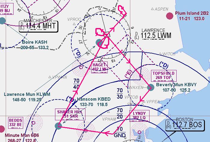
29 Apr 2006: Boston City Tour in a G1000.
I decided to check out in a G1000 glass cockpit Cessna 172SP. Except for the checks around the two electrical busses and arming the backup battery, the preflight was very similar to the steam gauge 172's I've flown before. Winds today were from the north which meant that Logan airport would be landing to the north with approaches over the bay....a good day to buzz around downtown. Since there was plenty of frost on other aircraft at Bedford and I was already deiced, it meant that htere wouldn't be much traffic heading the same direction. I called Boston Tower on their landline number and reserved a slot at 0800 to enter the BOS class bravo.
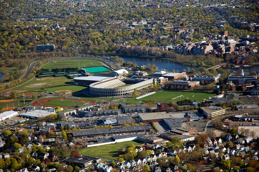
Takeoff was on Runway 5 and it was pretty weird trying to hold Vy on the climbout using the rolling airspeed tape. It took a couple of minutes to get used to it as we banked toward Boston's downtown buildings and I called up Boston Tower. Clearance was immediate at or below 1,200 feet, not a lot of leeway to maintain minimum ground clearance. I headed across Arlington and Cambridge, overflying Harvard University stad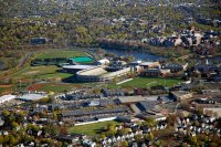 ium. built in 1904, it was the U.S. first collegiate sports stadium. After crossing the Charles River, the turbulence began to pick up a little making good photography a challenge. Opening the window didn't make for any better picture taking, just a lot of wind, noise and some seriously cold fingers!
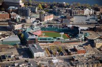
The next Stop was Fenway Park. I banked east beyond first base and got a good photo of the "Big Green Monster". Pity it wasn't Tuesday night when the Yankees would be playing.
 Out of the left window was he Prudential Center, Boston's second tallest building and a nice view of back bay.
 Another left turn pointed me amost due east, right at Logan Airport so I throttled back to about 90 knots to slow down the ride and take in more of the view. Passing by the Prudentia Ceter from the south, you can see 111 Huntington Ave., still within the Prudential center complex. Just beyond it is the Harvard bridge which connects Boston to the MIT campus on the far shore of the Charles river.
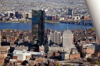 Continuing east, I passed the John Hancock building , New England's tallest skyscraper at 790 feet (60 stories). Next to it is the rectangular "Old" John Hancock building, built in the 1940's. The colored light on top changes every three hours according to the addage: "Steady blue, clear view.Flashing blue, clouds due.Steady red, rain ahead.Flashing red, snow instead." During baseball season, flashing red means the Boston Red Sox game has been called off.
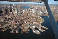
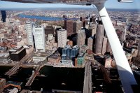 About the last point I took a picture was Fort Point Channel, an industrial waterway separating Boston and "Southie. The rectangular building is the Boston Federal Reserve Bank. The channel was drained during the Big Dig to build a section of tunnel which now underwater, leaks about 20 gallons per minute. This is the furthest point east I could proceed and turrned toward the north after passing over the World Trade Center and Boston Harbor. Any further east wuld be over Logan Airport itself!
 The bank north alows a nice downward view of Rowes Wharf and the Boston Harbor Hotel although turbulence from the building did pose a challenge to get a steady photo.
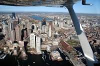
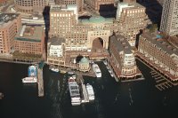
The flight then passed over India wharf and the New England Aquarium with great views of the old Cabot headquarters on State Street. The large brown building is the Marriott Hotel on Long Wharf. The Custom House clock is in the center of the picture.
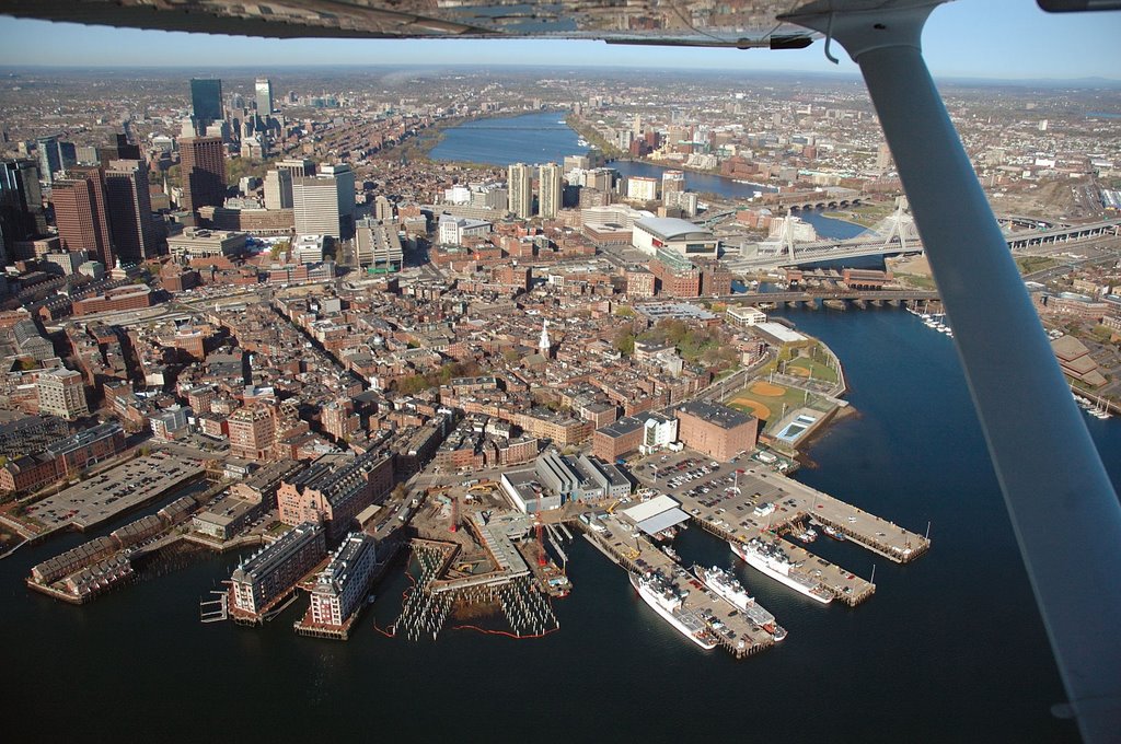
 Keeping slightly offshore, I passed over the North End, home to Boston's "Little Italy" just a short walk from Faneuill Hall.Just to the left of the wing strut, you can see the Zakim Bridge and the former Fleet Center immediately to the left of it.
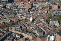 Near the center of the North End is Christ Church or the "Old North Church" where the two lanterns were hung on the evening of 18 April, 1775 signalling to Paul Revere that the British were to march on Lexington and Concord by sea.
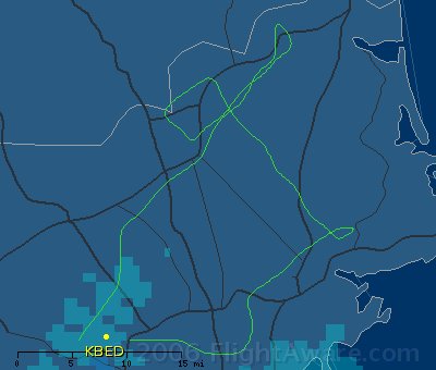
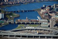 A final photo of the Boston Museum of Science with the Longfellow and Harvard Bridges in the background and I called Logan Tower to let them know I was going to track I-93 North at 1,200 feet to get out of the class bravo airpace. Once clear of it, I contacted Beverly tower for permission to cross their class delta airspace and head out east, toward Cape Ann.
Takeoff was on Runway 5 and it was pretty weird trying to hold Vy on the climbout using the rolling airspeed tape. It took a couple of minutes to get used to it as we banked toward Boston's downtown buildings and I called up Boston Tower. Clearance was immediate at or below 1,200 feet, not a lot of leeway to maintain minimum ground clearance. I headed across Arlington and Cambridge, overflying Harvard University stad
 ium. built in 1904, it was the U.S. first collegiate sports stadium. After crossing the Charles River, the turbulence began to pick up a little making good photography a challenge. Opening the window didn't make for any better picture taking, just a lot of wind, noise and some seriously cold fingers!
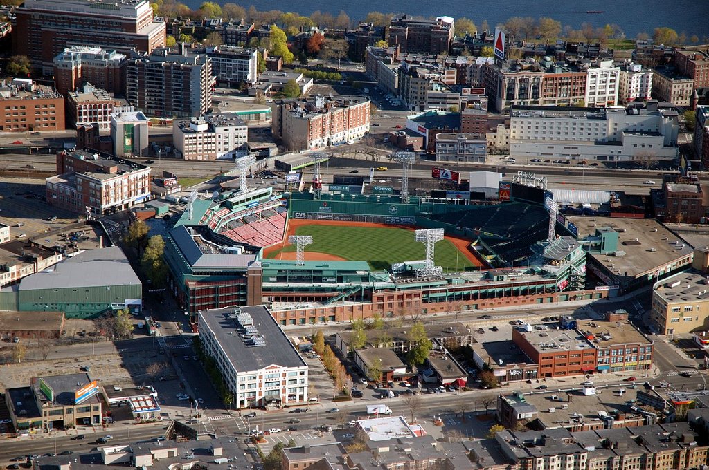
The next Stop was Fenway Park. I banked east beyond first base and got a good photo of the "Big Green Monster". Pity it wasn't Tuesday night when the Yankees would be playing.
Out of the left window was he Prudential Center, Boston's second tallest building and a nice view of back bay.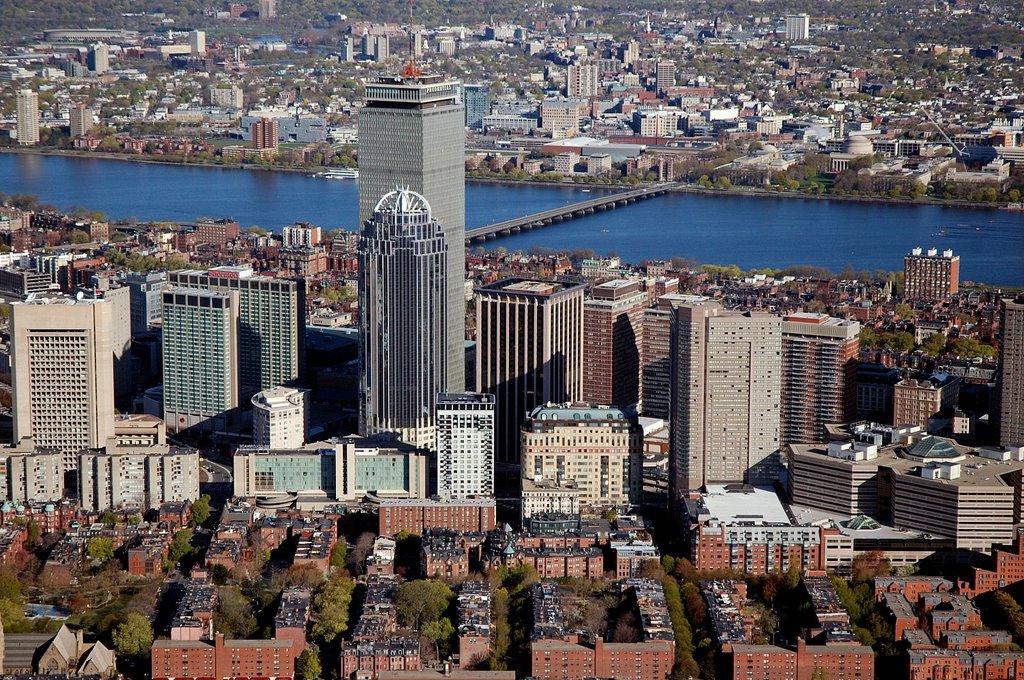 Another left turn pointed me amost due east, right at Logan Airport so I throttled back to about 90 knots to slow down the ride and take in more of the view. Passing by the Prudentia Ceter from the south, you can see 111 Huntington Ave., still within the Prudential center complex. Just beyond it is the Harvard bridge which connects Boston to the MIT campus on the far shore of the Charles river.
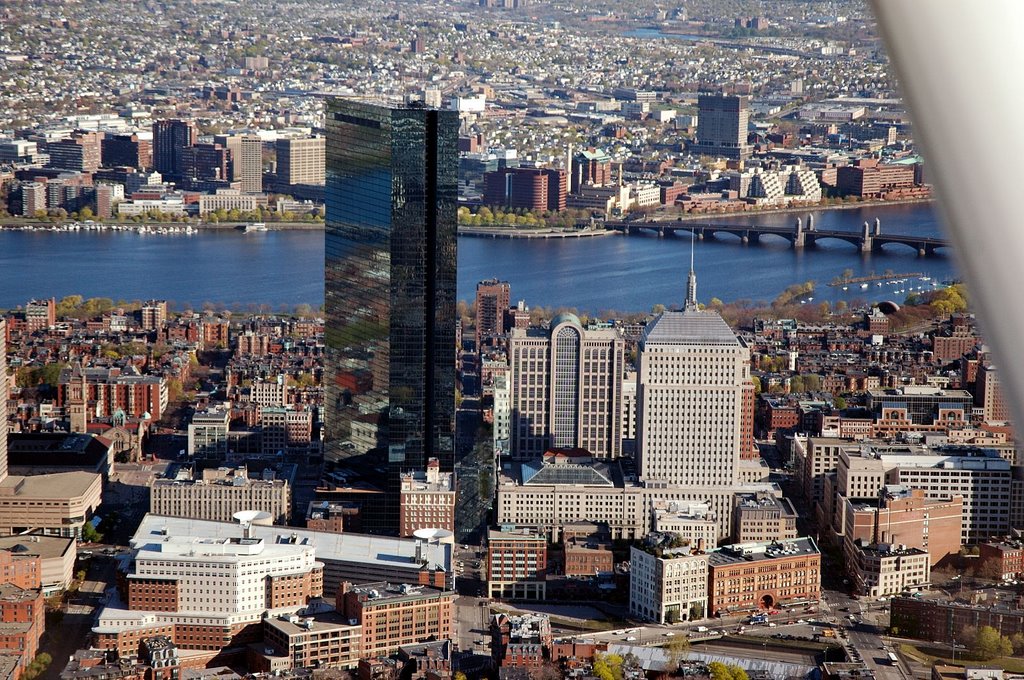 Continuing east, I passed the John Hancock building , New England's tallest skyscraper at 790 feet (60 stories). Next to it is the rectangular "Old" John Hancock building, built in the 1940's. The colored light on top changes every three hours according to the addage: "Steady blue, clear view.Flashing blue, clouds due.Steady red, rain ahead.Flashing red, snow instead." During baseball season, flashing red means the Boston Red Sox game has been called off.
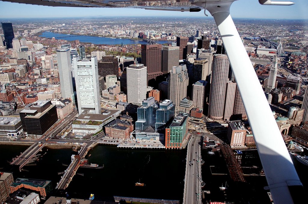 About the last point I took a picture was Fort Point Channel, an industrial waterway separating Boston and "Southie. The rectangular building is the Boston Federal Reserve Bank. The channel was drained during the Big Dig to build a section of tunnel which now underwater, leaks about 20 gallons per minute. This is the furthest point east I could proceed and turrned toward the north after passing over the World Trade Center and Boston Harbor. Any further east wuld be over Logan Airport itself!
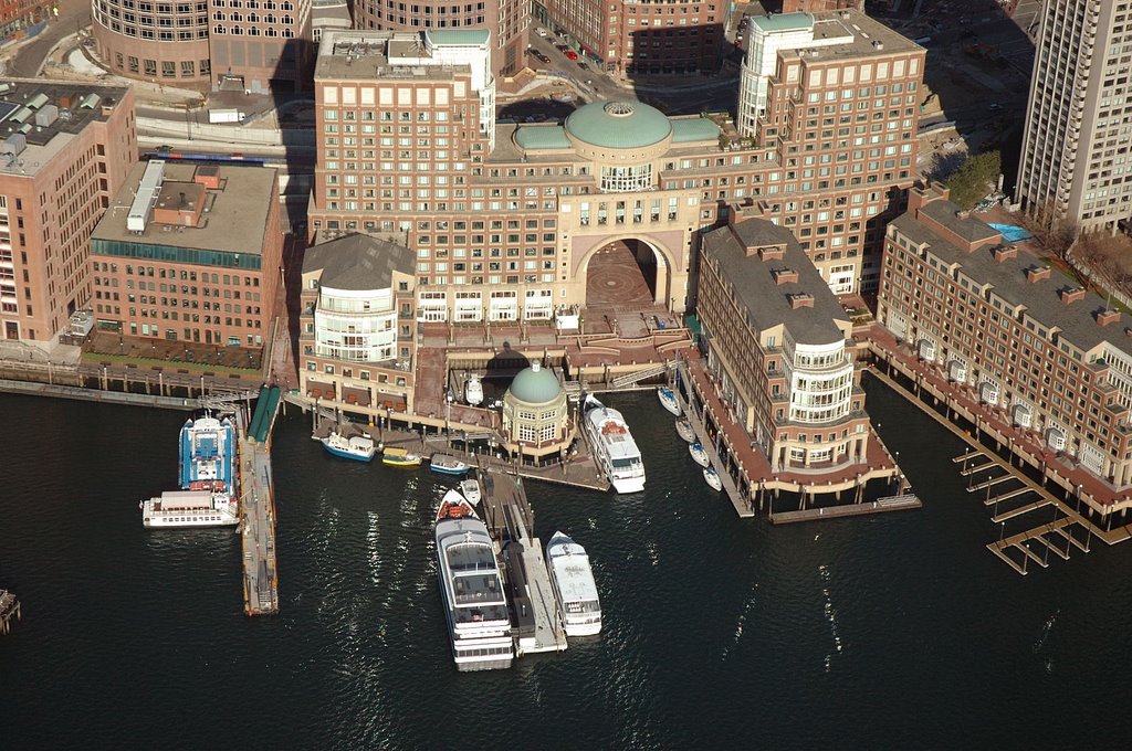 The bank north alows a nice downward view of Rowes Wharf and the Boston Harbor Hotel although turbulence from the building did pose a challenge to get a steady photo.
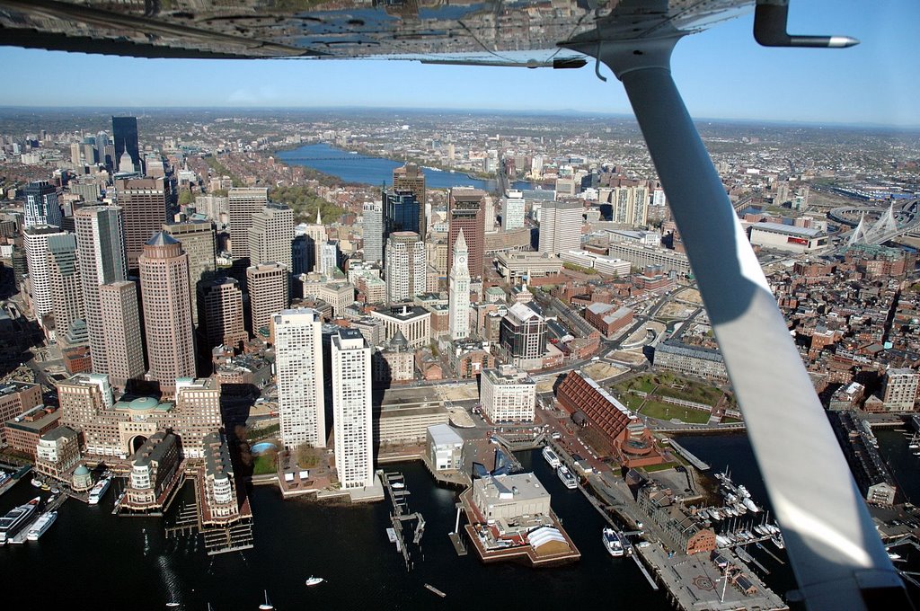
The flight then passed over India wharf and the New England Aquarium with great views of the old Cabot headquarters on State Street. The large brown building is the Marriott Hotel on Long Wharf. The Custom House clock is in the center of the picture.
 Keeping slightly offshore, I passed over the North End, home to Boston's "Little Italy" just a short walk from Faneuill Hall.Just to the left of the wing strut, you can see the Zakim Bridge and the former Fleet Center immediately to the left of it.
  Near the center of the North End is Christ Church or the "Old North Church" where the two lanterns were hung on the evening of 18 April, 1775 signalling to Paul Revere that the British were to march on Lexington and Concord by sea.
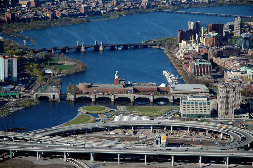 A final photo of the Boston Museum of Science with the Longfellow and Harvard Bridges in the background and I called Logan Tower to let them know I was going to track I-93 North at 1,200 feet to get out of the class bravo airpace. Once clear of it, I contacted Beverly tower for permission to cross their class delta airspace and head out east, toward Cape Ann.
posted by Robert at 8:31 PM
1 comments
![]()