21 Apr. 2006: Boston City Tour
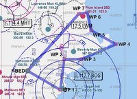
 There was a pretty nice onshore wind today so I decided to try for a city tour of Boston. Called Logan tower from Bedford letting them know we would be penetrating their airspace at 0800 and from the northwest. They told us to contat Logan tower directly on 128.8 when asking for permission to enter the class bravo airspace and maintain altitude 1300 to 1100 feet MSL, pretty low indeed! After taking off from Bedford, I aimed the nose of the plane directly at the Prudential tower and slowed to 90 knots while contacting Boston Tower. They were pretty busy handling traffic arriving from the south but that gave us the advantage of clear navigation over downtown without the danger of crossing an approach path. Finally..."Cessna 21693, cleared into the class bravo, maintain at or below 1,500.
I trimmed the plane out at 100 knots and 1,200 feet altitude and proceeded across Arlington, Belmont and finally across the Charles river turning left after passing abeam the Prudential tower and John Hancock building. The downtown skyskrapers were about 1,000 feet off of my left wing amd I passed over Ford Point Channel and banked left again over the World Trade Center. The view from over the harbor was spectacular.......Fanieul Hall and the Aquarium out of the left window and I could practically touch the heavy iron landing at Logan out of the right. Another left bank over the Zakim bridge put me right down the Charles River with great views of the BostonCommon, Espanade and Kendall square. Finally, after passing abeam of Fenway Park, a gentle roll to the right allowed a departure over Harvard's scarlet spire and a view of Cambridge. I tuned northeast and parallelled I-93 to get out of the class bravo before turning to the east and heading out to Cape Ann.
Boston Tower told me to squawk 1200 terminated radar service so I contacted Beverly to penetrate their class delta airspace at 1800 feet, dodging a pesky helicopter that was reporting traffic over I-93. Once clear of Beverly's airspoace I decented back down to 1200 feet and flew about 1/2 mile off of the southern shore of Cape Ann. The surf was pretty rough with the onshore wind but ot did meake for some dramatic effects as the waves broke around the lighthouses at Gloucester and Rockport, keeping clear of Thacher Island National Wildlife refuge. I cut across the peninsula just west of Pigeon Cove and across Lanesville and flew about a mile offshore north, past the Parker River National Wildlife refuge until Plum Island and the mouth of the Merrimack River. A left turn over Newburyport for a quick jaunt upriver gave pretty views of the U.S. 1 bridge crossing the river. I turned left to course of 245 degrees and headed back to Bedford.
Coming back I flew under Boston's class bravo airspace and just skirted Lawrence's airspace as I passed over Boxford, perfectly set up to enter a 45 degree left downwing for runway 11 at Bedford. Landing was uneventful and total time was about 1.4 hours on the Hobbs. This is a circuit to be repeatedagain and again.....what a great diversity of views and airspace. It was challenging to keep it all organized and keep up with Boston's communications but well worth it! Next time, I need to bring a photographer!

0 Comments:
Post a Comment
<< Home